


5 společenských her, které zabaví celou rodinu (nejen o Vánocích)
Říká se, že není důležité vyhrát, ale zúčastnit se. Zkuste to...


Kniha
297 Kč s DPH
Jsme transparentní


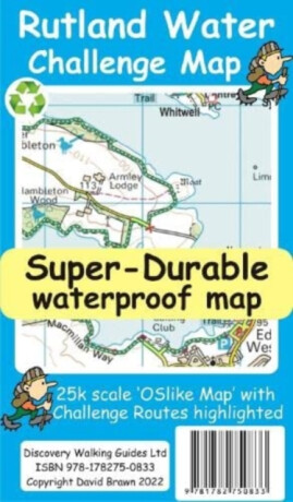
Rutland Water is the UK's largest man-made lake set in 4,200 acres of parkland including a wide, hard surfaced, walkway making the 'Water' an ideal introduction to long distance walking. There are four official, family friendly, recreation centres and nature reserves including the Rutland Osprey Project. Add in picturesque villages and the… Přejít na celý popis


5.0 z 5 hvězdiček
Voucher


5.0 z 5 hvězdiček
Voucher

5.0 z 5 hvězdiček
Voucher
Rutland Water is the UK's largest man-made lake set in 4,200 acres of parkland including a wide, hard surfaced, walkway making the 'Water' an ideal introduction to long distance walking. There are four official, family friendly, recreation centres and nature reserves including the Rutland Osprey Project. Add in picturesque villages and the town of Oakham and you will soon understand why Rutland Water has become one of England's favourite 'Daycation' destinations. Rutland Water Challenge Map and Guide is a 25k scale OSlike map with the Challenge route specially highlighted. We licence OS 50k scale mapping which is then doubled in size to produce an OSlike 25k map but the features, text and logos are now doubled in size making them much easier to read under Challenge conditions. Rutland Water Challenge Route is added and specially highlighted so that our route stands out against the OSlike 25k map. Then we add the additional detail you might need including local hostelries along with the three walking routes; Hambleton Peninsula 8.3kms, Circular 24.5kms and the full Challenge route at 36kms. For each of the three routes we have gps track and waypoints as a gpx file; the zip file of the gpx files is available as a free download. These gps track and waypoints gpx files can be used on all gps phone apps and gps units. The 33 waypoints of the full Challenge route are highlighted on the map, and our Rutland Water Challenge Map is available as a free digital Custom Map download for Garmin gps users. On the reverse of the map sheet is our Locator Map using OS Opendata showing the location of, and access to, Rutland Water relative to a wide area of England. The result is a double sided 600mm by 600mm map design. We then print the map design on a 100 micron plastic substrate using a special UV curing inks process on the UK's only press capable of using this latest technology. The result is a lightweight map that is both waterproof and tearproof, and fully recyclable, that will survive anything your Rutland Water Challenge can throw at it and afterwards will fold up like new.
0.0 z 5 0 hodnocení čtenářů
0× 5 hvězdiček 0× 4 hvězdičky 0× 3 hvězdičky 0× 2 hvězdičky 0× 1 hvezdička
Získejte přehled o vývoji ceny za posledních 60 dní.
Říká se, že není důležité vyhrát, ale zúčastnit se. Zkuste to...
V předchozím halloweenském čtení jsme se společně ponořili do umění...
Pro miliony diváků zůstane navždy kapitánem Jeanem-Lucem Picardem ze Star...
Co všechno musí vědět člověk, který komentuje finále mistrovství světa...
Tenhle rok vyšly dvě vlčí romantasy, které mě nesmírně bavily. Jednou z...
Pryč jsou dlouhé teplé letní večery, vládu už definitivně převzal...
Vánoce se pomalu blíží a s nimi také období, kdy bychom měli více myslet...
Z příběhu, který málem skončil v šuplíku, se nakonec stal více než...
Knižní závisláci, zbystřete! Největší knižní veletrh na Moravě se...
Měla být jeho minulostí. Stala se jeho posedlostí.
Po letech posedlosti se Kade vrací, aby si Stacey znovu získal – a tentokrát už jí nenechá uniknout.
Mohlo by vás zajímat
Jedna stará fotografie, tři generace žen a celé století rodinných tajemství
Lenka se vydává pátrat po minulosti své rodiny a postupně odhaluje příběhy několika generací poznamenaných tajemstvími i zvraty 20. století.
Mohlo by vás zajímat
Další kapitola postapo ságy je tady
Temná velekněžka a Šerif vyrážejí do Pustiny, kde vládnou nájezdníci a pravidla tu moc nectí. Čeká je nebezpečná výprava, tajemství a samozřejmě pořádná dávka akce.
Mohlo by vás zajímat
Vzorce pod kontrolou, chemie v malíčku!
Žádné bezradné koukání na chemické rovnice! Řešené příklady, přehledná shrnutí a procvičovací úlohy pomáhají pochopit učivo a získat větší jistotu při řešení chemických úkolů.
Mohlo by vás zajímat
Kočičí kletba útočí! Mňauhehe!
Výbušná koťátka se vracejí s pořádnou dávkou kočičí škodolibosti! Karty prokletí dokážou zamíchat každou partií a proměnit zdánlivě nevinný tah v naprostý chaos.
Mohlo by vás zajímat
Clawdeen je zpátky a má pořádné drápky!
Legendární vlkodlačí monsterka se vrací v ikonické podobě první generace Monster High. Původní design, stylové doplňky a pořádná dávka nostalgie dělají z této reedice příšerně skvělý sběratelský kousek.
Mohlo by vás zajímat
Podzim chutná po skořici!
Zachumlejte se do deky, vezměte do ruky oblíbený hrneček a nechte starosti za dveřmi. Skořicový zázrak přináší tu pravou atmosféru podzimních večerů, kdy se nikam nespěchá.
Každý měsíc společně přečteme tisíce knih






Tento web je chráněn službou reCAPTCHA a platí pro něj Zásady ochrany soukromí a Smluvní podmínky. | © 2001–2026 DOBROVSKÝ s.r.o. Všechna práva vyhrazena.








 KnihyDobrovsky.cz
 knihydobrovsky
 @knihydobrovskycz
 @knihydobrovsky