


Finále VisionQuestu zamíchalo kartami. Co znamená pro Avengers: Doomsday?
Marvel si zjevně řekl, že nás před premiérou Avengers: Doomsday nenechá...


Kniha ( měkká vazba )


Při zaslání zboží balíčkem
K nákupu nad 999 Kč dárek zdarma v hodnotě 349 Kč
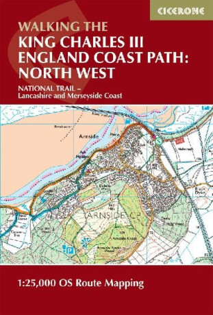
Covering a spectacular stretch of England’s newest National Trail, the King Charles III England Coast Path (KCIII ECP) winds its way along the dramatic shores of Lancashire and Merseyside. This evolving long-distance route showcases sweeping sandy beaches, estuary views, wildlife-rich saltmarshes and vibrant coastal towns, offering walkers a… Přejít na celý popis


5.0 z 5 hvězdiček
Voucher


Covering a spectacular stretch of England’s newest National Trail, the King Charles III England Coast Path (KCIII ECP) winds its way along the dramatic shores of Lancashire and Merseyside. This evolving long-distance route showcases sweeping sandy beaches, estuary views, wildlife-rich saltmarshes and vibrant coastal towns, offering walkers a unique blend of natural beauty, heritage and ever-changing sea vistas. The North West Lancashire and Merseyside Map Booklet is an essential navigation companion for anyone exploring this section of the trail. Compact yet highly detailed, it presents the full route on high-quality Ordnance Survey 1:25,000 mapping, ensuring accurate, easy-to-follow guidance whether you’re planning a multi-day adventure or enjoying shorter coastal walks. Complete coverage of the King Charles III England Coast Path National Trail through Lancashire and Merseyside on detailed Ordnance Survey 1:25,000 mapsClearly marked trail line with coastal access points, promenades, estuaries and key waypoints along the route from Arnside to ChesterSeamless, continuous mapping in a single booklet format suitable for walking in both directionsLightweight, durable and pocket-sized design, ideal for use in changeable coastal conditionsPerfect for both long-distance walkers and day hikers seeking reliable, on-the-go navigation A full Cicerone guidebook to the route is also available, offering detailed route descriptions and planning advice. You can also complete your North West collection with the Cumbria Map Booklet, sold separately. This inspiring stretch of coastline offers everything from windswept dunes and nature reserves to historic seaside resorts and bustling waterfronts. With the King Charles III England Coast Path Map Booklet – Lancashire and Merseyside in hand, you can explore with confidence and discover hidden corners of England’s north-west coast.
0.0 z 5 0 hodnocení čtenářů
0× 5 hvězdiček 0× 4 hvězdičky 0× 3 hvězdičky 0× 2 hvězdičky 0× 1 hvezdička
Získejte přehled o vývoji ceny za posledních 60 dní.
Marvel si zjevně řekl, že nás před premiérou Avengers: Doomsday nenechá...
Mezi tvými oblíbenými romány se rozsvítila malá japonská ulička. Má...
Listopad si přímo říká o večery strávené s knihou. Venku se brzy...
Po úspěšných knihách s Erikou Fosterovou a Kate Marshallovou se Robert...
Vánoce jsou za dveřmi a s nimi přichází i každoroční otázka: Co letos...
Další díl podcastu Buď inspirující je tady! Tentokrát naše pozvání...
Vánoce už pomalu klepou na dveře a s nimi přichází i každoroční otázka:...
Říká se, že není důležité vyhrát, ale zúčastnit se. Zkuste to...
V předchozím halloweenském čtení jsme se společně ponořili do umění...
Podzim chutná nejlépe v Kodani
Jonna nastoupí do kodaňské kavárny, jejíž majitel Mads jí brzy nabídne místo na svém hausbótu. Společně tráví stále víc času a Jonna zjišťuje, že mezi nimi vzniká něco víc než přátelství.
Mohlo by vás zajímat
Být sám sebou může být ten nejtěžší zápas
Kapitán týmu. Syn trenéra. Jeden tajný polibek, který změní vše...
Mohlo by vás zajímat
Kotletova nejdrsnější vyšetřovatelka znovu v akci
V budoucnosti, kde se technologie potkávají s nadpřirozenem, řeší vyšetřovatelka Eva Kosková případ technoboha. Na pomoc si přizve ajťáka i svého božského otce. Jenže tím problémy teprve začínají.
Mohlo by vás zajímat
Bradavice volají o pomoc!
Od prvních kouzelnických krůčků až po epický souboj s temnotou! Harry Potter: Boj o Bradavice vás provede sedmi příběhovými roky, během kterých budete získávat nová kouzla, spojence i schopnosti.
Mohlo by vás zajímat
Spirála plná malých objevů!
Pestrobarevná plyšová spirála promění postýlku, kočárek i autosedačku v malé království zábavy. Veselé barvy, zajímavé tvary a hebký materiál lákají miminko k pozorování a objevování.
Mohlo by vás zajímat
Vánoční cukroví v každém doušku!
Milujete vůni čerstvě upečených perníčků? Bio čaj Čas na perníček vám ji přinese přímo do hrnečku! Lahodná kombinace skořice, hřebíčku a dalšího voňavého koření promění každý doušek v malé vánoční potěšení.
Každý měsíc společně přečteme tisíce knih





Tento web je chráněn službou reCAPTCHA a platí pro něj Zásady ochrany soukromí a Smluvní podmínky. | © 2001–2026 DOBROVSKÝ s.r.o. Všechna práva vyhrazena.




 KnihyDobrovsky.cz
 knihydobrovsky
 @knihydobrovskycz
 @knihydobrovsky