


Finále VisionQuestu zamíchalo kartami. Co znamená pro Avengers: Doomsday?
Marvel si zjevně řekl, že nás před premiérou Avengers: Doomsday nenechá...


Kniha ( měkká vazba )
428 Kč s DPH
Jsme transparentní


Při zaslání zboží balíčkem
K nákupu nad 999 Kč dárek zdarma v hodnotě 349 Kč
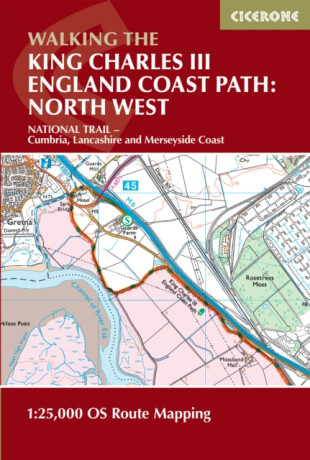
Covering the northern section of one of England’s most ambitious long-distance trails, the King Charles III England Coast Path in Cumbria offers a rich and varied coastal walking experience. Stretching from Gretna on the Scottish border to Grange-over-Sands, this dramatic route traces the shores of the Solway Firth and the fringes of the Lake… Přejít na celý popis


5.0 z 5 hvězdiček
Voucher


Covering the northern section of one of England’s most ambitious long-distance trails, the King Charles III England Coast Path in Cumbria offers a rich and varied coastal walking experience. Stretching from Gretna on the Scottish border to Grange-over-Sands, this dramatic route traces the shores of the Solway Firth and the fringes of the Lake District, combining expansive estuaries, rugged shoreline and ever-changing coastal landscapes. The North West Cumbria Map Booklet is an essential navigation companion for anyone exploring this section of the trail. Compact yet highly detailed, it presents the full route on high-quality Ordnance Survey 1:25,000 mapping, ensuring accurate, easy-to-follow guidance whether you’re planning a multi-day adventure or enjoying shorter coastal walks. Full route coverage of the King Charles III England Coast Path National Trail across Cumbria on Ordnance Survey 1:25,000 mapsClearly highlighted route line with access points, coastal features, harbours and key locations between Gretna and Grange-over-SandsContinuous mapping presented in a single, easy-to-use booklet for travel in either directionLightweight and compact format, well-suited to carrying in changing coastal weather conditionsIdeal for both long-distance walkers and those planning shorter day walks A companion Cicerone guidebook is also available, providing in-depth route descriptions and planning guidance. You can also pair this booklet with the Lancashire and Merseyside Map Booklet to complete your North West England Coast Path collection. From expansive salt marshes and open tidal flats to historic ports and coastal viewpoints backed by mountain scenery, this section of the route highlights the quieter, wilder side of England’s coastline. With the Cumbria map booklet to hand, you can navigate confidently and experience this unique landscape at your own pace.
0.0 z 5 0 hodnocení čtenářů
0× 5 hvězdiček 0× 4 hvězdičky 0× 3 hvězdičky 0× 2 hvězdičky 0× 1 hvezdička
Získejte přehled o vývoji ceny za posledních 60 dní.
Marvel si zjevně řekl, že nás před premiérou Avengers: Doomsday nenechá...
Mezi tvými oblíbenými romány se rozsvítila malá japonská ulička. Má...
Listopad si přímo říká o večery strávené s knihou. Venku se brzy...
Po úspěšných knihách s Erikou Fosterovou a Kate Marshallovou se Robert...
Vánoce jsou za dveřmi a s nimi přichází i každoroční otázka: Co letos...
Další díl podcastu Buď inspirující je tady! Tentokrát naše pozvání...
Vánoce už pomalu klepou na dveře a s nimi přichází i každoroční otázka:...
Říká se, že není důležité vyhrát, ale zúčastnit se. Zkuste to...
V předchozím halloweenském čtení jsme se společně ponořili do umění...
428 Kč s DPH
Jsme transparentní
Dva soupeřící vrazi. Jedna nebezpečná posedlost.
Mara Eldritchová se ocitne mezi dvěma rivaly, z nichž každý má vlastní temné úmysly. Jeden ji chce využít, druhý je jí posedlý. A oba jsou nebezpečnější, než vypadají.
Mohlo by vás zajímat
Od stydlivého kluka, který miloval sport, až po hlas českého hokeje
Robert Záruba v knize vypráví o své cestě ke komentátorskému mikrofonu i o více než 2000 přenosech.
Mohlo by vás zajímat
Kdo smí rozhodnout o konci?
Když se eutanázie stane legální možností, musí se Nora rozhodnout o životě své těžce nemocné dcery. Příběh jedné rodiny otevírá otázky o utrpení, lásce a právu rozhodovat o smrti.
Mohlo by vás zajímat
Pohádka, kterou tvoříte společně!
Vstupte do kouzelného světa Dixitu, kde každý obrázek vypráví tisíc příběhů. Popusťte uzdu představivosti, vymýšlejte originální nápovědy a nechte ostatní hádat, co se vám honí hlavou!
Mohlo by vás zajímat
HUNTR/X hlásí další hvězdu do sbírky!
Mira v ikonickém outfitu z vystoupení „Golden“. S růžovými vlasy, stylovou bundičkou a výrazným pódiovým vzhledem je připravená zazářit na scéně i v boji proti démonům.
Mohlo by vás zajímat
Chybičky? Ty jednoduše odletí!
Překlep nebo nepovedené písmenko? Žádný problém! Díky gumovatelnému růžovému inkoustu a integrované gumě zmizí chyby bez škrtání a nevzhledných šmouh.
Každý měsíc společně přečteme tisíce knih




Tento web je chráněn službou reCAPTCHA a platí pro něj Zásady ochrany soukromí a Smluvní podmínky. | © 2001–2026 DOBROVSKÝ s.r.o. Všechna práva vyhrazena.




 KnihyDobrovsky.cz
 knihydobrovsky
 @knihydobrovskycz
 @knihydobrovsky